 |
New York 288 (Sandy Creek to Smartville, 1930s) |
| Decommissioned: | c. 1940 |
| Western Terminus: | US 11, Sandy Creek |
| Eastern Terminus: | Oswego CR 50, Smartville |
| Length: | 6.33 miles (10.19 km) |
| Orientation: | East-West |
| Counties: | Oswego |
| Cities: | None |
| Villages: | Sandy Creek, Lancona |
| Towns: | Sandy Creek, Boylston |
| Name(s): | |
| Replaced By: | Oswego CR 15 |
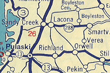
Scan from the 1935 Sunoco Rand McNally New York
state map showing the original NY 288 alignment
in Oswego County.
|
No photos have been submitted.
If you have photos to submit, please contact us. |
 | |
 (1940-81) | |

|
 |

|

|
Page Created: September 4, 2022 | Page Updated: September 4, 2022