 |
New York 276 (Clarksville to Richburg, 1930s) |
| Decommissioned: | Early 1940s |
| Western Terminus: | NY 94 (Now NY 305), Clarksville |
| Eastern Terminus: | NY 275, Richburg |
| Length: | 7.30 miles (11.75 km) |
| Orientation: | East-West |
| Counties: | Allegany |
| Cities: | None |
| Villages: | Richburg, Bolivar |
| Towns: | Clarksville, Wirt |
| Name(s): | |
| Replaced By: | Allegany CR 40 |
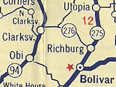
Scan of the 1935 Sunoco Rand McNally New York state map
showing the original NY 276 alignment in Allegany County.
|
No photos have been submitted.
If you have photos to submit, please contact us. |
 | |
 (1940s) |
 (1963-Present) |

|
 |

|

|
Page Created: September 4, 2022 | Page Updated: September 4, 2022