 |
New York 181 (Pamelia to Black River, 1960-63) |
About |
Photos/Videos |
Links |
| Decommissioned: | 1963 |
| Western Terminus: | NY 12, Pamelia |
| Eastern Terminus: | NY 3, Black River |
| Length: | 8.37 miles (13.48 km) |
| Orientation: | East-West |
| Counties: | Jefferson |
| Cities: | None |
| Villages: | Black River |
| Towns: | Pamelia, LeRay |
| Name(s): | Leray St. |
| History: |
The more recent NY 181 alignment was assigned in 1960, but was dropped three years later out of concerns motorists would confuse it with I-81 which was being built nearby about the same time. |
| Replaced By: | NY 342, Jefferson CR 129 |
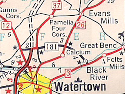
Scan from the 1960 Esso General Drafting map |
About |
Photos/Videos |
Links |
|
No photos have been submitted.
If you have photos to submit, please contact us. |
About |
Photos/Videos |
Links |
| Wikipedia: New York 181 |
 | |
 (1930-40) | |

|
 |

|

|
Page Created: August 15, 2006 | Page Updated: March 13, 2021