 |
New York 21A |
About |
Photos/Videos |
Links |
| Decommissioned: | Early 1940s |
| Western Terminus: | NY 21, Woodville |
| Eastern Terminus: | US 20 / NY 5, Canandaigua |
| Length: | 17.02 miles (27.40 km) |
| Orientation: | North-South |
| Counties: | Yates, Ontario |
| Cities: | None |
| Villages: | None |
| Towns: | Italy, Middlesex, Rushville, Canandaigua |
| Name(s): | Sunnyside Rd., East Lake Rd. |
| History: |
NY 21A originally began at NY 21 in the Hamlet of Woodville at the south end of Canandaigua Lake. The exact routing from Woodville to Vine Valley is unknown. However the 1940 Sinclair Rand McNally New York state map shows NY 21A routed along town maintained roads or roads that no longer exist along the eastern shore of Canandaigua Lake. NY 21A's southern terminus was truncated to Vine Valley in 1939 and the designation as a whole decommissioned in the early 1940s. |
| Replaced By: | Yates CR 39, Ontario CR 11, NY 364 |
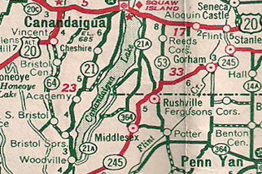
1940 Sinclair Rand McNally New York |
About |
Photos/Videos |
Links |
|
No photos have been submitted.
If you have photos to submit, please contact us. |
About |
Photos/Videos |
Links |
| Wikipedia: New York 21A |

|
 |

|

|
Page Created: October 15, 2020 | Page Updated: October 15, 2020