 |
New York 439 |
About |
Photos/Videos |
Links
| Decommissioned: |
1972 |
| Western Terminus: |
NJ Line at Staten Island (Continued as NJ 439) |
| Eastern Terminus: |
Staten Island Ferry Terminal |
| Length: |
7.31 miles (11.77 km) |
| Orientation: |
East-West |
| Counties: |
Richmond |
| Cities: |
New York |
| Villages: |
None |
| Towns: |
None |
| Name(s): |
Forest Ave., Victory Blvd., Bay St. |
| Replaced By: |
I-278, NYCDPW Maintained |
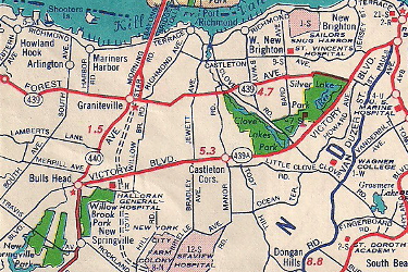
Scan from the 1952 Sunoco Rand McNally New York state
map showing NY 439's alignment.
About |
Photos/Videos |
Links
|
No photos have been submitted.
If you have photos to submit, please contact us.
|
About |
Photos/Videos |
Links
Page Created: July 14, 2006 |
Page Updated: September 6, 2020


