 |
New York 347 (Ticonderoga, 1934-52) |
| Reassigned: | 1952 |
| Western Terminus: | NY 22, Ticonderoga |
| Eastern Terminus: | Ticonderoga-Larrabee's Point Ferry |
| Length: | 1.66 miles (2.67 km) |
| Orientation: | East-West |
| Counties: | Essex |
| Cities: | None |
| Villages: | Ticonderoga |
| Towns: | Ticonderoga |
| Name(s): | |
| Replaced By: |
NY 73 (1952-73) NY 74 (1973-Present) |
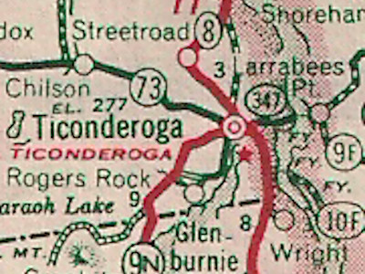
1940 Sinclair Rand McNally New York State map showing |
About |
Photos/Videos |
Links
If you have photos to submit, please contact us.
Page Created: October 10, 2022 |
Page Updated: October 10, 2022


(1930-34)

(1966-Present)


