 |
New York 338 (Whitesville to West Union, 1930-40) |
| Decommissioned: | c. 1940 |
| Western Terminus: | NY 17G (Now NY 248), Whitesville |
| Eastern Terminus: | PA Line at West Union |
| Length: | 4.87 miles (7.84 km) |
| Orientation: | East-West |
| Counties: | Allegany, Steuben |
| Cities: | None |
| Villages: | None |
| Towns: | Independence, West Union |
| Name(s): | None |
| Replaced By: | Allegany CRs 19 and 19A, Steuben CR 124 |
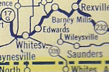
1935 Sunoco Rand McNally New York State map showing |
About |
Photos/Videos |
Links
If you have photos to submit, please contact us.
Page Created: October 9, 2022 |
Page Updated: October 9, 2022


(1940-80)
(1980-96)


