 |
New York 330 |
| Decommissioned: | 01/24/1980 |
| Southern Terminus: | Tompkins CR 115, Guide Board Corners |
| Northern Terminus: | NY 79, Brooktondale |
| Length: | 5.29 miles (8.52 km) |
| Orientation: | North-South |
| Counties: | Tompkins |
| Cities: | None |
| Villages: | None |
| Towns: | Caroline, Dryden |
| Name(s): | Central Chapel Rd., Valley Rd., Brooktondale Rd. |
| Replaced By: | Tompkins CR 115 |
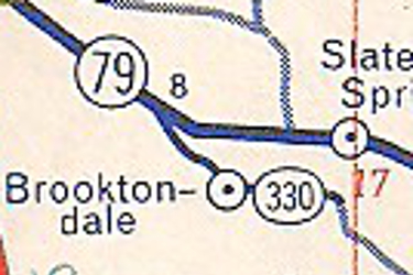
1971 Gulf New York State map showing the NY 330 alignment.
|
No photos have been submitted.
If you have photos to submit, please contact us. |
| Wikipedia: New York 330 |

|
 |

|

|
Page Created: July 17, 2006 | Page Updated: August 23, 2020