 |
New York 77A |
| Decommissioned: | 1935 |
| Western Terminus: | Tonawanda Indian Reservation |
| Eastern Terminus: | NY 77, Basom |
| Length: | 0.98 miles (1.58 km) |
| Orientation: | East-West |
| Counties: | Genesee |
| Cities: | None |
| Villages: | None |
| Towns: | Alabama |
| Name(s): | Bloomingdale Rd. |
| Replaced By: | NY 267 (1935-80) |
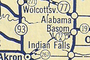
Scan from the 1935 Sunoco Rand McNally New York
state map showing the NY 77A alignment.
|
No photos have been submitted.
If you have photos to submit, please contact us. |

|
 |

|

|
Page Created: October 10, 2020 | Page Updated: March 6, 2021