 |
New York 61 (Suffern to West Haverstraw, 1930-31) |
About |
Photos/Videos |
Links |
| Reassigned: | 1931 |
| Western Terminus: | NY 17, Suffern |
| Eastern Terminus: | US 9W, West Haverstraw |
| Length: | 11.63 miles (18.72 km) |
| Orientation: | East-West |
| Counties: | Rockland |
| Cities: | None |
| Villages: | Suffern, Montebello, Pomona, West Haverstraw |
| Towns: | Ramapo, Haverstraw |
| Name(s): | Wayne Ave., Haverstraw Rd., Ramapo Rd., Westside Ave. |
| History: | The original NY 61 alignment was a holdover from the 1924-30 numbering system. |
| Replaced With: | US 122 (1931-34), US 202 (1934-Present) |
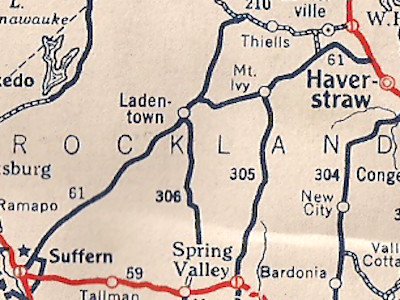
Scan from the 1930 Socony Rand McNally New York state map |
About |
Photos/Videos |
Links |
|
No photos have been submitted.
If you have photos to submit, please contact us. |
About |
Photos/Videos |
Links |
 | |
 (1934-40s) |
 (1958-Present) |

|
 |

|

|
Page Created: March 20, 2022 | Page Updated: March 20, 2022