 |
New York 47 (Rochester, 1937-80) |
About |
Photos/Videos |
Links |
| Decommissioned: | 03/18/1980 |
| Western Terminus: | NY 104, Rochester |
| Eastern Terminus: | NY 18, Rochester |
| Length: | 15.57 miles (25.07 km) |
| Orientation: | East-West |
| Counties: | Monroe |
| Cities: | Rochester |
| Villages: | None |
| Towns: | Greece, Gates, Brighton, Irondequoit |
| Name(s): | Long Pond Rd., Howard Rd., Brooks Ave., Genesee Park Blvd., Elmwood Ave., Winton Rd. |
| History: |
In the Rochester area, the NY 47 designation followed a semicircuitous loop mainly through the surrounding suburbs. The original alignment began at US 104 at the current Mall at Greece Ridge Center site, and followed Long Pond and Howard Roads, Brooks Ave., Genesee Park Blvd., Elmwood Ave., and Winton Rd., with its eastern terminus at US 104 (Present day NY 404). As new expressways were built around the city, portions of NY 47 were moved off surface streets and onto the newly built expressways. The final alignment had NY 47 start at what is now the NY 390/NY 104 interchange in Greece. NY 47 then followed NY 390, I-390, Plymouth Ave., Elmwood Ave., I-590, and NY 590 to the eastern terminus at NY 18 (What is now the E. Ridge Rd. exit). |
| Replaced By: |
NY 390 (W. Ridge Rd./NY 104 to I-490), I-390 (I-490 to NY 383), NY 383 (I-390 to Elmwood Ave.), I-590 (Elmwood Ave. to I-490), NY 590 (I-490 to E. Ridge Rd.), NY 204 (Brooks Ave. Section) |
| Recommendation: | Assign NY 47 to replace NY 9N between Lake George (US 9) and Ticonderoga (NY 22/NY 74) |
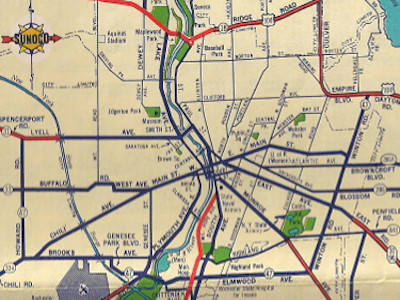 Scan from the 1952 Sunoco Rand McNally New York state map showing NY 47's pre-expressway alignment around Rochester. |
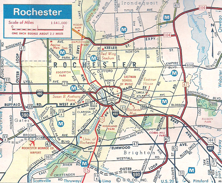 Scan from the 1975 Marine Midland General Drafting New York state map showing NY 47's final Rochester alignment. |
About |
Photos/Videos |
Links |
|
No photos have been submitted.
If you have photos to submit, please contact us. |
About |
Photos/Videos |
Links |
| Wikipedia: New York 47 |
 |
 (1930-36) |

|
 |

|

|
Page Created: December 2, 2006 | Page Updated: February 27, 2021